Hoosier Chapter Fall Gathering 2014

Posted:
Mon May 19, 2014 9:56 amby Kurt (Indiana)
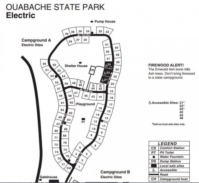
Ouabache State Park will be the location for our fall gathering. When: October 9-12, 2014Reservations are being taken now so please don't wait.
Reservations LinkThere are local area activities around this weekend and the park will fill up fast.
More details to come but our sites should be in the north loop surrounding the shower hose and the shelters. sites 17-60 or in the vicinity would be good.
Re: Hoosier Chapter Fall Gathering 2014
Posted:
Tue May 20, 2014 9:14 amby indycamper
Sharon - 24
Verna and Sunny Day - 26
Re: Hoosier Chapter Fall Gathering 2014
Posted:
Wed May 21, 2014 6:54 amby Kurt (Indiana)
The Fall gathering is quite popular already.
Here are the sites reserved so far:
Kurt - 21
Sharon - 24
Verna - 26
Mike D - 34
Jim & Vicki - 31
Bob H - 33
Please reserve as soon as you can. There are local events scheduled for this weekend and the sites will go fast.
Re: Hoosier Chapter Fall Gathering 2014
Posted:
Wed Jun 11, 2014 7:52 pmby Kurt (Indiana)
The Fall gathering is quite popular already.
Here are the sites reserved so far:
Kurt - 21
Alan & Cathy - 22
John & Rose - 23
Sharon - 24
Verna - 26
Gerry S- 28
Mike D - 34
Jim & Vicki - 31
Bob H - 33
Jim & Cindi - 42
Please reserve as soon as you can. There are local events scheduled for this weekend and the sites will go fast.
Re: Hoosier Chapter Fall Gathering 2014
Posted:
Thu Jun 12, 2014 9:12 amby Jst83
Wow that falls center weekend of the Boy's fall break, I'm seeing a 4 day weekend in my future

Re: Hoosier Chapter Fall Gathering 2014
Posted:
Sun Jun 22, 2014 8:50 amby Tripmaker
Cindi and I will be in site 42.
Re: Hoosier Chapter Fall Gathering 2014
Posted:
Sun Jul 20, 2014 2:34 pmby Kurt (Indiana)
The Fall gathering is quite popular already.
Here are the sites reserved so far:
Rick & Leona - 20
Kurt - 21
Alan & Cathy - 22
John & Rose - 23
Sharon - 24
Verna - 26
Rich & Val - 27
Gerry S- 28
Mike D - 34
Jim & Vicki - 31
Bob H - 33
Jim W- 39
Jim & Cindi - 42
Please reserve as soon as you can. There are local events scheduled for this weekend and the sites will go fast.
Re: Hoosier Chapter Fall Gathering 2014
Posted:
Sun Jul 20, 2014 2:36 pmby Kurt (Indiana)
Ouabache State Park will be the location for our fall gathering. When: October 9-12, 2014Reservations are being taken now so please don't wait.
Reservations LinkThere are local area activities around this weekend and the park will fill up fast.
More details to come but our sites should be in the north loop surrounding the shower hose and the shelters. sites 17-60 or in the vicinity would be good.
Re: Hoosier Chapter Fall Gathering 2014
Posted:
Mon Jul 21, 2014 3:02 pmby Kurt (Indiana)
Don't forget to make your reservations for the Fall Gathering. The park will fill up fast.
Re: Hoosier Chapter Fall Gathering 2014
Posted:
Mon Jul 21, 2014 10:03 pmby Rick & Leona
We're signed up for site #20. We loved Starve Hollow!!! We're going back again soon. See you all in October.
Re: Hoosier Chapter Fall Gathering 2014
Posted:
Wed Jul 30, 2014 6:50 pmby Kurt (Indiana)
Another History Lesson Ouabache State Park Learn and enjoy
As the Laurentide ice sheet began to retreat from present day Northern Indiana and Northwest Ohio between 14,000 and 15,000 years ago, it receded into three distinct lobes. The eastern or Erie Lobe sat atop and behind the Fort Wayne Moraine. Meltwater from the glacier fed into two ice-marginal streams, which became the St. Joseph and St. Marys Rivers. Their combined discharge was probably the primary source of water for the proglacial Wabash River system.
As the Erie Lobe of the glacier continued to retreat its meltwater was temporarily trapped between the ice front to the east and the Fort Wayne Moraine to the west, and formed proglacial Lake Maumee, the ancestor of modern Lake Erie. Around 11,000 years ago the waters of Lake Maumee became deep enough that it breached a "sag" or weak spot in the Fort Wayne Moraine. This caused a catastrophic draining of the lake which in turn scoured a 1 to 2 mi (1.6 to 3.2 km) wide valley known as the Wabash-Erie Channel or "sluiceway." The Little (Wabash) River flows through this channel and U.S. 24 traverses it between Fort Wayne and Huntington. The valley is the largest topographical feature in Allen County, Indiana.
When the ice melted completely from the region, new outlets for Lake Maumee's water opened up at elevations lower than the Wabash-Erie Channel. While the St. Josepth and St. Marys Rivers continued to flow through the channel, Lake Maumee no longer did. Now a low-lying, probably marshy bit of terrain lay in between.
It is not known for certain when, but at some point in the distant past he St. Joseph and St. Marys Rivers jumped their banks and flooded the marshy ground of the Fort Wayne Outlet. The discharge of this unusual flood was enough to cut across the outlet and come into contact with the headwaters of the Maumee River. Once this happened, the flood waters rushed to the east into the Maumee River, and their erosive force was enough that the new channel cut across the Fort Wayne Outlet into the Maumee River was at a lower elevation than that of the sluiceway. This meant that when the flood waters receded, the sluiceway was permanently abandoned by the two rivers. As a result of capturing them both, the Maumee was converted from a minor creek to a large river. Once again, river waters flowed through the Fort Wayne Outlet, but now they flowed eastward, toward Lake Erie, instead of westward. Following this event, the branch of the Wabash River that originates along the Wabash Moraine near Bluffton became the system's main course and source.
The name "Wabash" is an English spelling of the French name for the river, "Ouabache." French traders named the river after the Miami Indian word for the river, waapaahšiiki, meaning "it shines white", "pure white", or "water over white stones". The Miami name reflected the clarity of the river in Huntington County, Indiana where the river bottom is limestone.
The Wabash was first mapped by French explorers to the Mississippi, including the sections now known as the Ohio River.[3] Although the Wabash is today considered a tributary of the Ohio, the Ohio was considered a tributary of the Wabash until the mid-18th century. This is because the French traders traveled north and south from Canada to the Gulf of Mexico via the Wabash; it served as a vital trade route for North American-French trade.
The United States has fought five battles on or near the river; the Battle of Vincennes (1779), St. Clair's Defeat (1791), the Attack on Fort Recovery (1794), the Battle of Tippecanoe (1811), and the Siege of Fort Harrison (1812). Different conflicts have been referred to as the "Battle of the Wabash". A 329-acre (133 ha) remnant of the old-growth forests that once bordered the Wabash can be found at Beall Woods State Park, near Mount Carmel, Illinois. In the 19th century, the Wabash and Erie Canal, one of the longest canals in the world, was built along much the river. Portions are still accessible in modern times, but most of the abandoned canal no longer exists.
The Wabash River between Terre Haute and the Ohio River was navigable by large ships during much of the 19th century, and was a regular stop for steamships. By the late 19th century, erosion due to farming and runoff made the Wabash impassible to such ships. Dredging could have resolved the problem, but was not undertaken because railroads had become the preferred form of transport. The 200 mile stretch south of Terre Haute includes several inoperable swing bridges.
The river has shifted course several times along the Indiana and Illinois border, creating cutoffs where parts of the river are entirely in either Indiana or Illinois. However, both states generally regard the middle of the river as the state border.